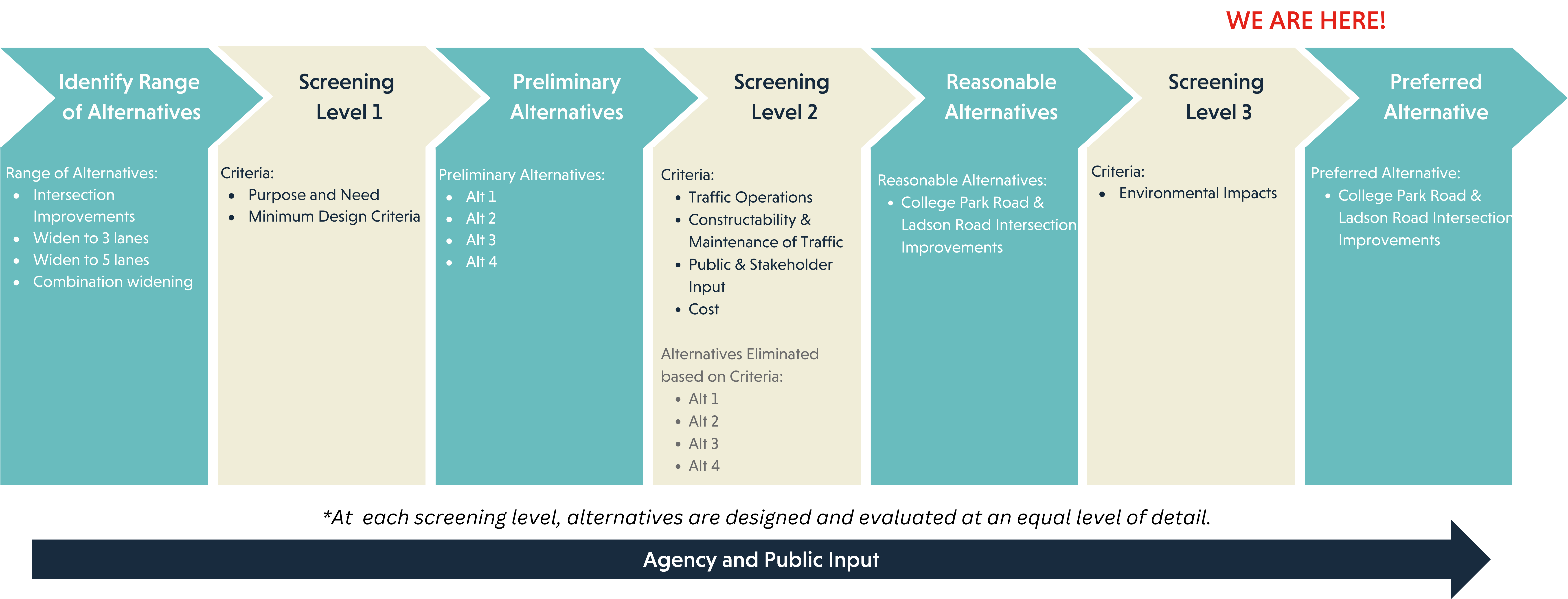
Alternatives 

Overview of Process to Determine, Present, and Select Feasible Alternatives

Initially, a range of alternatives are developed based upon past and ongoing alternatives and studies, stakeholder and public input/recommendations, agency input, and design standards. Once this range of alternatives are established, they are funneled through a 2 tiered screening process.
Tier 1 Screening
The Tier 1 Screening evaluates each alternative to determine if it meets the primary purpose and need as well as minimum design criteria. The alternatives that pass this screening will move forward to the Tier 2 Screening.
Tier 2 Screening
The Tier 2 Screening will evaluate which of the preliminary alternatives (from the Level 1 Screening) best meet the primary purpose and need while also considering the degree to which these alternatives meet the secondary purpose and need, their impacts on the natural and human environment, estimated project costs, and overall feasibility. Only the alternatives that meet these criteria will be advanced for consideration as Reasonable Alternatives.
The alternatives that are not eliminated through the Tier 2 Screening process will be further refined through preliminary engineering before detailed impact analyses begin for the environmental assessment. The preliminary design for roadway will include details such as number of lanes, horizontal and vertical alignments, typical sections, right of way limits, intersection layouts, and construction limits.

Each reasonable alternative will be designed to a similar level of detail. Once the preliminary design work is complete, the potential effects of the alternatives will be identified and compared at an equal level of detail. The reasonable alternatives will be detailed in the Environmental document with the ultimate goal of selecting a Preferred Alternative that would meet the overall purpose and need of the project while avoiding and minimizing environmental impacts to the greatest extent practicable.

In this section

Newsletter sign up

Please enable JavaScript in your browser to complete this form.

Alternative Analysis

A Range of Alternatives was developed using data from previous studies, traffic modeling and evaluation, environmental impacts, agency input, and community and stakeholder input. The Range of Alternatives were funneled through Screening Level 1, which evaluated each alternative based on the purpose and need and minimum design criteria.

Alternatives that passed Screening Level 1 are considered Preliminary Alternatives, shown as Alternatives 1 - 4. The Preliminary Alternatives will now be funneled through Screening Level 2, which will evaluate each alternative based on the following criteria:
  • Traffic Operations
  • Constructability & Maintenance of Traffic
  • Public & Stakeholder Input
  • Cost
Alternatives that pass Screening Level 2 will be considered Reasonable Alternatives. Reasonable Alternatives will undergo additional design and analysis.
Alternatives ScreeningView Graphic
View Graphic
View Graphic

Ladson/College Park

In 2019, after reviewing traffic studies for the Lowcountry Rapid Transit project, Charleston County identified that the 3 intersections at Hwy 78 at College Park Road, Hwy 78 at Ladson Road, and Ladson Road at College Park Road are key to traffic delays experienced in the corridor. The traffic study included four alternatives consisting of multiple configurations to help alleviate current congestion experienced at these intersections and a traffic analysis was performed to review each configuration. Alternative 4 was selected as the Preferred Alternative for the Ladson/College Park Intersection and it will be evaluated in more detail as part of the Hwy 78 project design.

Intersection Preferred Alternative

  • Relocates the intersections of US 78at College Park Road and Ladson Road at College Park Road.
  • Signalizes the intersection of Ladson Road at College Park Road.
  • Reconfigures US 78 at the intersection of US 78 at Ladson Road.
  • Ancrum Road approach becomes right-in/right-out.
  • Widens College Park Road to a 5- lane section between US 78 and Ladson Road.

Traffic Improvements

When comparing the Level of Service (LOS) between a three-lane section (consisting of two travel lanes and a two-way center turn lane) from Berlin G. Myers to the Fairgrounds (Alternative 2) and a five-lane section (with four travel lanes and a two-way center turn lane) in the same area (Alternatives 3 and 4), the three-lane section exhibits better performance and experiences less decline in the later year (2049) as analyzed in the traffic study. While a five-lane section would offer additional capacity, it also is shown to attract more traffic to the corridor for users from the Summerville area to access I-26 and points east.

View Graphic

Traffic Analysis

The Project Team completed a Traffic Study that analyzed the existing and future conditions for the no-build and the build alternatives. This study looked at Level of Service at intersections along the corridor and segments of Hwy 78. The project team then uses this data to determine how an alternative meets the purpose and need of the project.

Years analyzed: 2029, 2039 and 2049.

Incorporated Projects:
  • Lowcountry Rapid Transit 30% Design
  • Berlin G. Myers Pkwy Extension
Traffic volumes:
  • Approximately 48,000 daily vehicles south of College Park Road/Ladson Road area
  • Approximately 16,000 daily vehicles north of College Park Road/Ladson Road area
View GraphicView Graphic
Charleston County Public Works 
Transportation Engineering
Lonnie Hamilton III Public Services Building
4045 Bridge View Drive, Suite B309
North Charleston, SC 29405
© Highway 78 Corridor. 
Privacy Policy Legal Disclaimer
linkedin facebook pinterest youtube rss twitter instagram facebook-blank rss-blank linkedin-blank pinterest youtube twitter instagram